Iron Age and Celtic Montacute
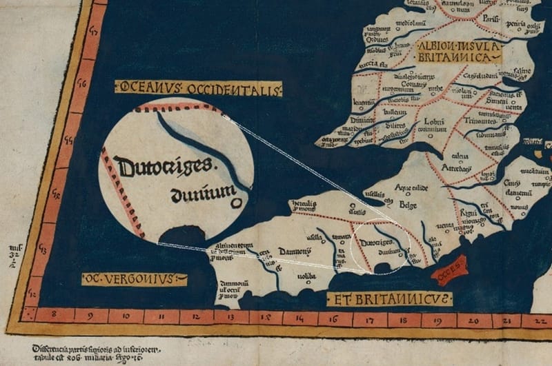
Image: Close-up of a 1486 reproduction of Ptolemy's map showing British tribes in the 2nd century AD, with a focus on the Durotriges region. The full Prima Europa Tabula map can be viewed on Wikipedia.
Montacute’s history goes back thousands of years, with evidence of human activity dating from prehistoric times. Modern humans first settled in Somerset around 12,000 to 9,000 years ago (The Archaeology of Somerset, Ed. M. Aston and I. Burrow, 1982). Not far from Montacute, some of the oldest man-made roads in Great Britain, like the Post Track and Sweet Track, were built across the Somerset Levels, with dates going back to 3,838 BCE.
Montacute is part of a region where human settlement has been continuous. Just two miles west of the village centre, spanning Montacute, Stoke and Norton parishes, Ham Hill hillfort has produced remains from the Upper Paleolithic through Iron Age and Roman to modern times. Montacute lies within the area controlled by the Durotriges at the time of the Roman conquest (The Archaeology of Somerset, Ed. Aston and Burrow, 1982, p. 61).
Aston and Burrow (The Archeology of Somerset,1982) and more recent excavations (2011, 2012 and 2013, summarised in 'Excavations at Ham Hill, Somerset 2011-2013: Post-Excavation Assessment' (Britain et al. 2015) record finds from the Upper Paleolithic (13,000-10,000 BC), Mesolithic (10,000-4,000 BC), Neolithic (4,000-2,500 BC), late Bronze Age (2,500 to 800 BC), and Iron Ages (800 BC to 43 AD). Iron Age iron currency bars and coins from the Celtic Durotriges tribe have been found there (Seaby 1949, https://www.jstor.org/stable/42661417). The Durotriges occupied Ham Hill until it was sacked by the future Emperor Vespasian and the Roman Second Legion in 45AD, although most other Celtic tribes had stopped using hillforts by this time.
Click here to check out Dr. Marcus Brittain's talk on Youtube about the excavations on Ham Hill.
Consideration of grave goods and a genetic analysis of burials at Winterbourne Kingston (25 miles south-east of Montacute) by Cassidy et al in January 2025 indicates that Iron Age and Early Bronze Age communities featured high status females who stayed in the same locality while the males travelled to other communities. The authors suggest this 'matrilocality' and a social system defined by maternal inheritance "is associated with societies in which wealth is concentrated in the land, which is typically abundant and extensively farmed and owned by women, and in which men are often absent (for example, because of warfare)". Romans of this period noted that British society was unusual in having female power centres, rather than the more common pattern where men held local power while women married into alliances elsewhere. An uncommon maternal inheritance marker—mitochondrial DNA haplotype U5b1—was prevalent in a set of Durotrigan burials dating from 153 BC to 35 AD, and interestingly, this same maternal marker was also found in Cheddar Man, (c. 8,000 BC) and also in a modern-day relative, whose maternal lineage in Somerset has been traced back 300 years. (His relatedness to Cheddar Man through the female bloodline would span approximately 300 generations). However, this maternal marker (which occurs at a frequency of 1 in 10,000) was not found in 14 burials at Ham Hill from around 250–300 BC. I have not yet determined whether these burials were male or female—perhaps they were incoming men?
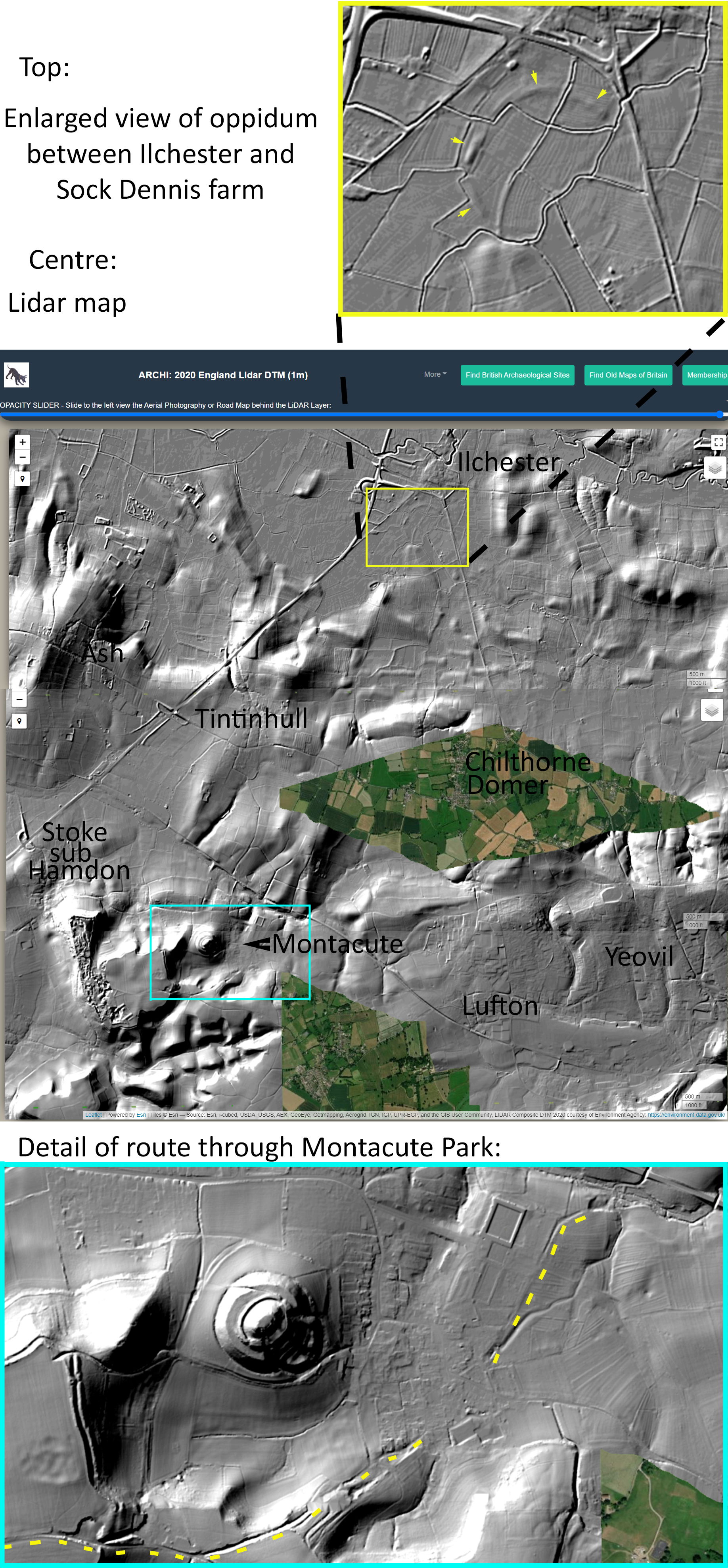
Archaeologist Miranda Richardson recorded the discovery of Iron Age pottery in Montacute Park, and there was probably a route between Montacute and a fortified Iron Age settlement (oppidum) near Ilchester and Sock Dennis Farm (Somerset Historic Environment Record 53089). There’s also evidence of a possible circular henge on private land at Stanchester, just north of Montacute and Ham Hill.
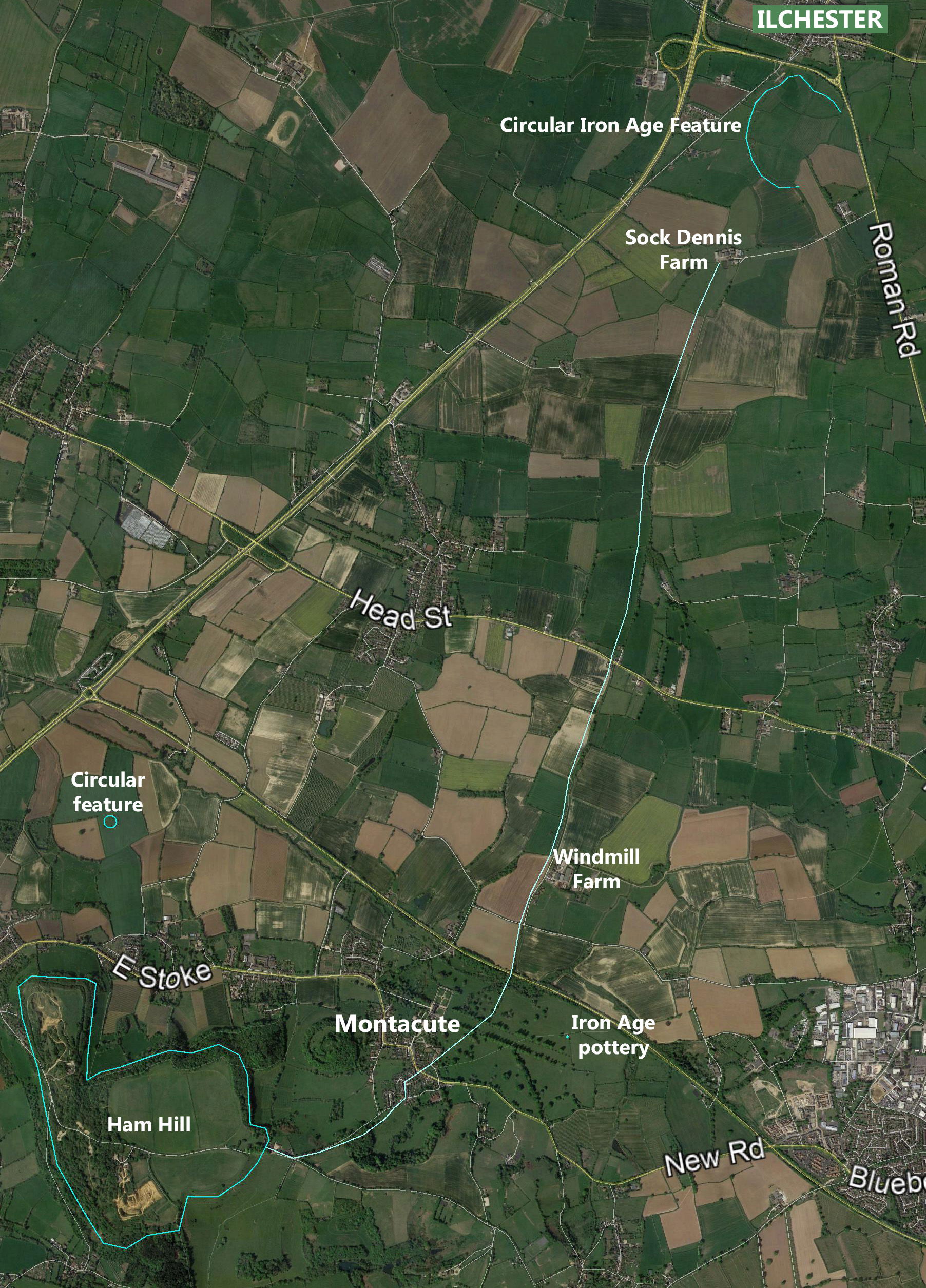
A trackway runs from the Iron Age settlement near Ilchester/Sock Dennis through Montacute and up to Ham Hill, entering the hill on the eastern side. This route is highlighted in pale blue on the map above, with the section through Montacute marked in green on the map below. The Leland Trail, believed to have been taken by John Leland around 1542 AD, follows this path. Starting at Ilchester, it passes Sock Dennis Farm, follows Sock Lane, and crosses Head Street/Yeovil Road into Kissmedown Lane. (Kissmedown Lane's name is intriguing—it could be linked to a lovers’ meeting spot, but it could also refer to the plant Arum maculatum, which is known colloquially as cuckoo pint or lords and ladies, but also as 'kitty-come-down-the-lane').
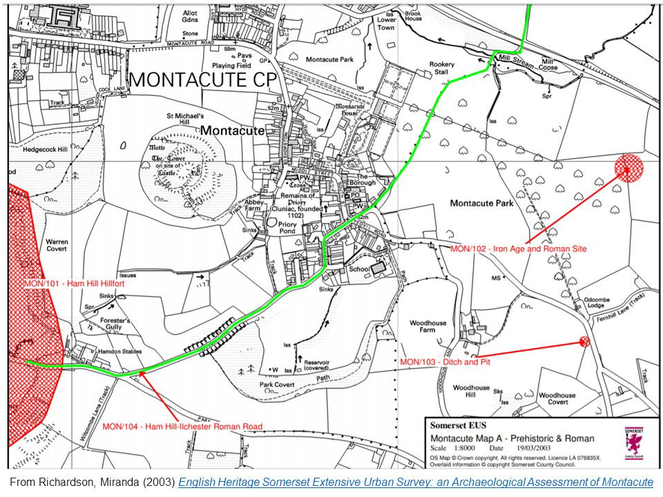
From Kissmedown Lane, the track passes Windmill Farm, crosses the present-day A3088, and moves past the remains of Montacute (Odcombe) Mill, which is marked as 'Mill Stream' on the map. It then enters Montacute Park, although the exact route through the park is less clear, passing the present-day east frontage of Montacute House, before emerging onto Back Lane in Montacute village. Here, the Leland Trail continues through the village, across the recreation ground north of the Tower, and on through Hedgecock Woods towards Ham Hill.
In her 2003 archaeological assessment of Montacute, Miranda Richardson notes that a Roman track followed much the same route. After Back Lane, it diverged slightly, passing through Townsend, up Hollow Lane (shown as a cutting on the map), and along the road from Odcombe (Park Lane) to Ham Hill. By the 18th century, the London to Exeter coach road followed a different route, running from Yeovil through Odcombe and across Ham Hill. Llewelyn Powys even mentions a milestone near Five Ashes at the top of Woodhouse Lane, marking the distance to London as 127 miles.
The pictures below illustrate the same route on LIDAR maps (LIght Detection And Ranging) and its geographical relationship to Ilchester and the late Iron-Age oppidum.